
SwRI demonstrates autonomous drones at nuclear power plant
Southwest Research Institute (SwRI) has developed a drone with simultaneous localization and mapping (SLAM) technology that can operate fully autonomously without any prior knowledge of its environment.
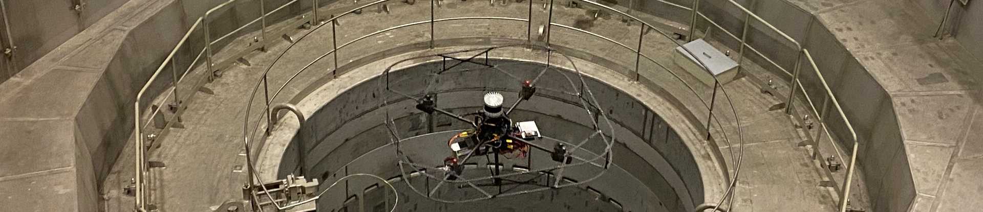
SwRI tested the autonomous drone's capabilities during the EnRicH 2021 European robotics hackathon. During the hackathon, the drone was tasked with entering the Zwentendorf nuclear power plant (Austria) and locating radiation sources without human pilot assistance.
The team built a drone that used new algorithms and computer vision to explore and map unknown environments. The drone is equipped with a LiDAR sensor, a time-of-flight (TOF) camera and radiation detectors. During the trial, the team used onboard and ground processors to perform SLAM, exploration, decision-making, autopilot, computer vision analysis, sensing and other tasks.
“We demonstrated our research drone, which allows a system to map new spaces and navigate them without help from a human operator, and it performed well despite difficult conditions. The research drone proved itself in both artificial and natural environments, such as caves”

The SwRI unmanned aircraft successfully detected two sources of cobalt-60, a radioisotope hidden in different locations as part of the task. Participants had no prior information about the object or the reconnaissance challenges set by the judging panel.
The Zwentendorf nuclear power plant is located about 32 km northwest of Vienna. It is the only nuclear power plant in the world that was completed but never put into operation. It was built in 1978 and loaded with fuel, but Austria then decided it did not trust nuclear energy, and the project was abandoned.
“The drone demonstrated high flexibility, skillfully operating in previously unknown environments. It proved its ability to adapt, learn and carry out tasks in real time, which is critical in time-sensitive search-and-rescue and hazardous scenarios”
Unlike other mapping technologies that require a robot to move around an area to map it, the SwRI drone can display the spatial topography of indoor structures and open spaces in real time as it explores the area autonomously.

“Modern drones and ground robots typically place heavy demands on human operators. The autonomy we demonstrated can significantly reduce the burden on operators, allowing robotic systems to act independently and work on their own”
According to him, the engineers developed a fully autonomous stack that can be combined with various sensors and UAV platforms to carry out mission-critical tasks.
The SwRI drone can be used for work that is dangerous for humans, such as assisting in hazardous search-and-rescue operations, as well as inspecting hazardous facilities at industrial plants or infrastructure sites after natural disasters.
Using algorithms and simulation tools, the technology displays the spatial topography of indoor structures and open spaces in real time. By combining data from computer vision sensors, the technology plans routes as it learns new areas. Perception methods for detecting people, vehicles and other objects based on convolutional neural networks (CNN) are also available.
At EnRicH 2021, SwRI received an award for UAV mapping. SwRI took part in two of the three events: the research event and the search-and-rescue event. The goal of the event is to give developers the opportunity to test their technologies in real environments.
SwRI's autonomy stack has been used in everything from commercial and military connected and autonomous ground vehicles to automated drones and intelligent agricultural equipment. It uses open-source tools such as the Robot Operating System (ROS), proprietary machine learning algorithms and artificial intelligence.
SwRI is not the only organization developing such technologies. In April 2021, Exyn Technologies announced that it had reached Level 4A autonomy, meaning it can fly freely in complex spaces. At this level, there is no need for a human operator who could take control of the system at any time.
Exyn drones are now capable of exploring complex spaces in free flight with full flight path planning, while moving at speeds of up to two or more meters per second. In addition, obstacle avoidance and path tracking are performed onboard the drone. There is no need to connect the drone to additional computing resources. At the same time, the device can collect higher-quality data in larger volumes. In ideal conditions, Exyn drones can cover 16 million cubic meters in a single flight, equivalent to nine football stadiums.
SwRI is a leader in science and engineering from the deep sea to deep space. The company develops interdisciplinary technical solutions that benefit government and commercial clients worldwide.


